Inlay Resource Center (literature,Culture, Research & Development )
Introduction
Situation , the width and environment of Inlay
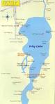
Inlay Lake is one of the main tourist attraction in Myanmar eand the most beautiful place in Asia with floating gardens, Floating markets, beautiful landscape and traditional cultivation on floating island. Other attractive scene is the boat rowing by leg and big horn-shaped fishing trap lakeInle is famous for its high historical cultured vale of PhaungDawOo Pagoda located at the heart of the Lake.Inlay Lake, the second largest island natural lake in Myanmar is situated in NyaunShwe Township, Taunggyi District in the southern part of the Shan State. It is rising to 884 m above sea level 20.93 km length and 4.8 km, maximum depth is 4 pm. The shape of the inlay lake is elliptical from tapering edges in the north and south. Direct use of the inlay lake is fishing, water gardening, transportation, electricity production and tourism. A large percentage of the whole country’s electricity supplies totally depend on Lawpita hydroelectricity plant, which relies on the lake water supply. The lake was formed 650million years ago and it was believe that human settlement started since 10 000 years ago.
Inlay Lake is one of the main tourist attraction in Myanmar eand the most beautiful place in Asia with floating gardens, Floating markets, beautiful landscape and traditional cultivation on floating island. Other attractive scene is the boat rowing by leg and big horn-shaped fishing trap lakeInle is famous for its high historical cultured vale of PhaungDawOo Pagoda located at the heart of the Lake.Inlay Lake, the second largest island natural lake in Myanmar is situated in NyaunShwe Township, Taunggyi District in the southern part of the Shan State. It is rising to 884 m above sea level 20.93 km length and 4.8 km, maximum depth is 4 pm. The shape of the inlay lake is elliptical from tapering edges in the north and south. Direct use of the inlay lake is fishing, water gardening, transportation, electricity production and tourism. A large percentage of the whole country’s electricity supplies totally depend on Lawpita hydroelectricity plant, which relies on the lake water supply. The lake was formed 650million years ago and it was believe that human settlement started since 10 000 years ago.
Background
In the township of Nyang Shwe Inle Lake, in situated on the southwest of Nyaung Shwe , in TaungGyi District in southern Shan State.On the east and west sides of Inle Lake, being beautified by the surrounding mountain ranges.On the east side of the Inle Lake ,There are TaungGyi Division and Hsehseim Division,on the west side of it Kalaw Division and on the north side it ,the TaungGyi Township and on the south ,PheKon Township. Besides the Inle Lake is larger than Kain Daw Gyi in Kachin state. But Inlay Lake is the second Largest Lake in Myanmar.
In the Lake ether are full of water running from the north to south the surface of the Lake is in the height of 2950 feet. above the sea level; it is very significant as a Lake among the mountains in Shan Plateau. Inle Lake was once twice the size of present Inle Lake and about the size of the place of Nyanung Shwe and Inle Lake combined.(It existed ad two seals in size than as it is now.
It usually rains in Inle June to November and average annual rainfall is 39.46 inches .The minimum temperature during the hottest month ,March is 36 degrees centigrade and the cold season of December is 2 degrees Centigrade.There are 16 streams from the east, one stream from the North and 12 streams from the west flowing into Inle Lake .Most of them are water felling from the higher mountains In Inle Lake is wide from the north ,at the beginning of the lake ,being Ai Htaung Gyi village ,Inn Oo village to Nampam village.Inlay Lake becomes smaller and smaller after when it flows from the place of Nampam village to the south ,and it is like as a stream.There are many various plantations on the both sides of the stream and there are also many mountains ranges on the east and west sides.When water of Inle Lake reaches the south part of the lake, It is called Beelu Chaung running into the Than Lwin River .There is 80 ft. wide in an average .
Average water surface of Inle Lake is about 7 ft in the depth. It usually rains in Inle Lake during the month of October average annual rainfall is 20 ft. and during the summer especially March, rainfall is about at least 12 ft in the depth.Around the Lake there forty one currents which are running into the Lake ,are expect many streams flowing into the Lake.
Water condition
Pleasant weather condition is favorable for crop production in this area. The residents earned their living by cultivation of crops on floating gardens. The people living on the floating islands produce domestic waste, human sewages, debris, the waste of chemical compound of inorganic fertilizer, pesticides utilized in the agriculture farming on the floating islands. Inappropriate cultivation practices, deforestation, wetland and agriculture lands lead to unwanted erosion in hill side cultivation.Forest and bush are cleared, and wetlands are encroached to create for human settlement, livestock and agricultural purposes. Siltation is considered to be a major threat during the rainy season, when rain causes erosion of soil which has been subjected to forest fires in the dry season. So inlay Lake has been narrowing year by year because of soil erosion and siltation.Inlay lake was found to be abundant in aquatic plants, floating plants, water hyacinths, water lilies, submerged plants and algae blooms in and around the lake. This condition in the lake leads to eutrophic condition.The natural beauty of the lake attracts many tourists. Many hotels,resorts and restaurants have also been developed on the shore of the lake, which may cause an increase in the flow of the domestic effluent into the lake,which may cause an increase in the flow of the domestic effluent into the lake,Because of urbanization and floating islands.Inlay Lake is currently under stress mainly due to natural and human pressure such as deforestation and shifting cultivation in the watershed as well as high concentration of population,water pollution,eutrophication and decreasing biodiversity. Thus technical measures and survey are urgently required to check environmental degrading, to prevent erosion of the lake watershed, to converse the inlay lake and to ensure water enough to generate hydropower.
Pleasant weather condition is favorable for crop production in this area. The residents earned their living by cultivation of crops on floating gardens. The people living on the floating islands produce domestic waste, human sewages, debris, the waste of chemical compound of inorganic fertilizer, pesticides utilized in the agriculture farming on the floating islands. Inappropriate cultivation practices, deforestation, wetland and agriculture lands lead to unwanted erosion in hill side cultivation.Forest and bush are cleared, and wetlands are encroached to create for human settlement, livestock and agricultural purposes. Siltation is considered to be a major threat during the rainy season, when rain causes erosion of soil which has been subjected to forest fires in the dry season. So inlay Lake has been narrowing year by year because of soil erosion and siltation.Inlay lake was found to be abundant in aquatic plants, floating plants, water hyacinths, water lilies, submerged plants and algae blooms in and around the lake. This condition in the lake leads to eutrophic condition.The natural beauty of the lake attracts many tourists. Many hotels,resorts and restaurants have also been developed on the shore of the lake, which may cause an increase in the flow of the domestic effluent into the lake,which may cause an increase in the flow of the domestic effluent into the lake,Because of urbanization and floating islands.Inlay Lake is currently under stress mainly due to natural and human pressure such as deforestation and shifting cultivation in the watershed as well as high concentration of population,water pollution,eutrophication and decreasing biodiversity. Thus technical measures and survey are urgently required to check environmental degrading, to prevent erosion of the lake watershed, to converse the inlay lake and to ensure water enough to generate hydropower.
|
Topography
Inlay lake was formed at the low plain surrounded by high mountains. At the middle there is a flat land elongated from north to south forming a fertile land for agriculture.Streams flow into the lake from surrounding mountains, there are 29 streams and rivers of all sizes flowing into the lake.But only four major streams Nam let Chaung, Negya(Yebye) ChaungkalawChaung and Nan Pilu(Balu)Chaung are most important. The elevation ranged from 847 m at the lake surface and ranges 2043 m at the SingaungTaung. Eastern watershed was composed of steep slopes with dense vegetation cover compared with the west where the land is rather gentle slope and occupied by various agricultural lands. Shifting cultivation can be refound where hilly areas with steep slopes both side of the lake. It is obvious that if permanent agriculture could not be established, then shifting cultivation was the only way to support the livelihood in hilly region. |
Soil Type
Four types of soil are found in Inlay watershed, Aacrisol, Cambisol, Gleysol(e) and Gleyol(d) ,Fluvisol. Acrisol or red earth soil are the most domination soils of the whole watershed and the yellow soil occurs on lower slopes. These soils have a very deep profile having the texture varying sandy and silty to silty clay loan with good structure as well as drained and easy to plough; the soil reaction was slightyy acidic to neutral before but now pH ranging from 7.79 to 8.46 Iron and aluminum contents are considerably high while nitrogen and phosphorus are deficient.Yellow brownish soil (Cambisol-histic) dominated lowland and flat plain engulfed by mountains from the East and West .Mostly the area was un-forested or few natural forests largely occupied by cast agriculture land and pastures. Since the area has little vegetation cover throughout the year, soil disturbances are most likely to be happened such as rainfall induce and soil compaction in pasture lands which, in turns, increased soil and water losses from the surface . Gleysol (meadow alluvial soils) are found at the southern west regions where KalawChaung ,a major tributary to the , Formed alluvial soils across Aungban plain. The texture is silty clay loan and widely utilized for oilseeds such as agricultures, Sesame, sunflower as well as cereals. It has neutral SOIL reaction and is rich in available plant nutrients compare with other two soil types. |
Hydrology
The water surface area of the lake is about 100 km2 in wet season and 70 km2 in dry season .It now 11 km at the longest and 5 km at the wiedest .It used to have 36 mil(km) length and 8 mail(km) width with water surface area of 100 mile2 (forest Dept; Taunggyi) Nowadays ,the depth also reduced to 20 feet in monsoon and 12 feet in summer in 2006 and it could be much less by now. Streams flow into the lake from surrounding mmountains, four major streams are Nam let Chaung ,Negya (yebei) chaung and Nam pilu (balu)chanung. The rate of siltation from inflowing stream is 623,000 m3 /year, and clearing the natural vegetation for cultivation accelerates siltation (Ma 1996). Climate Inlay watershed received rain during monsoon season which last for five months from mid-may to mid-oct .The mean annual rainfall is about 1400 mm. Generall , rainfall was intense at the beginning and end of the season whilst there was an obvious drought period forming bimodal rainfall pattern. The surrounding highland areas received more rainfall than the valley due to differences in elevation range. The annual temperature ranges from 12.C in the summer. |
History of Inlay Lake
The ways to Inle Lake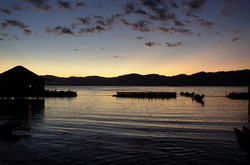
If you want to go to Inle Lake, you have to go to NyaungShwe and to continue to Inle lake by motor boat.We can go directly from Yangon to Inle by car and ot can be arrived by the train from Yangon to Shwe Nyanung and by boat from Nyaung Shwe to Inle. By sir from Yangon to He-Ho and by car He-Ho to Nyaung Shwe .it is about 19 miles from TaungGyi the capital of southern Shan state .We can go easily by car there.Over the small bank of the stream and ranges of mountains and belt of forests there is a very pleasant lake as a small sea round the hillock and hillsides ,when it being looked on the brow of the mountains range above the place of the Inle Lake. NyaungShwe can be said to enter the gate way of the Inle Lake ,so we have to go to Inle Lake from it. By the voyage to Inle Lake we can go by boat or Motorboat. By the land ,we can go by car from Mine Thauk to Nampan Market.There is a 100 ft wide on the west side of the lake being the length of 4 miles around the west of the lake toward the beginning of the lake .There are also many plantations and forests and villages which are built after the ground being made as the foundation of the ground .There are many breading and fisheries in small lakes, villages, various plantations and moors and reeds on the west of the small bank of the lake.
အင္းေလးမွလွိဳက္လွဲစြာႀကိဳဆိုပါ၏
ေရလွိဳင္းေဖြးေဖြး အင္းေလးကန္တြင္
ၾကာရနံ႕ဆင္း ႀကိဳင္သင္းအင္းတစ္ခြင္ ေလေျပညင္ညင္ ေဆာ္လွ်င္တေသြး အင္းေလးကန္သာ ပန္းေရႊၾကာ နံ႕သာပ်ံ႕ကာ ေမႊးသည္ႏွင့္ေလး ။ ေတာင္ျပာရစ္ေထြး အင္းေလးကန္တြင္ ေဖာင္ေတာ္ဦးမွ ဖူးရဘုရားရာဇ၀င္ ျမန္းၾကြႏွစ္စဥ္ အင္းျပင္တလႊား ေဒသစာရီ ျမန္းၾကြခ်ီ ဘုရာ႕ တန္ခိုးႀကီးမားသည္ႏွင့္ေလး။ အင္းသူအင္းသား စိတ္ထားျဖဴစင္ ယဥ္ေက်းသိမ္ေမြ႕ ဓေလ့အမွန္ပင္ ေမးၾကေခၚငင္ ခင္မင္ေစေၾကာင္း လွိဳက္လွဲႀကိဳဆို အင္းသူပ်ိဳ ႏွဳတ္ခ်ိဳသေလာ လြန္ေကာင္းသည္ႏွင့္ေလး။ မိသဂၤဟအေပါင္း ေဆြးေဟာင္းေရာင္းရင္းလွ်င္ အင္းေလးစခန္း၊ ေရာက္လွမ္းခဲ့ေစခ်င္ အျပဳံးနဲ႕ပင္ ၾကည္လင္ပ၀င္း လက္ကမ္းလွ်က္သာ ဖိတ္ေခၚကာ တို႕မွာေရႊလလင္းၾကသည္သို႕ေလး ။ ဆည္းဆာညခင္း လွယမင္း မယ္လဲဂမုဒ္ ပန္းဆက္ေရာ႕မည္ သည္းညွာမွဆင္း ခဏတြင္း ေမာင္လဲႏွုတ္ခြန္း ဆက္ေတာ့သည္။ စံႏြယ္ထြန္း(အင္းေလး) |
History of Inle Lake
Inle Lake is very famous .Many mountains ranges are around the lake and lake-dwellers built their houses in the shallow water of the lake. Besides , they row the boats with their legs and plants the vegetables and crops on the floating islands.
During October ,Thidingyut ,Phaungdaw Oo pagoda has been going trimerantly from place to place in the Inle Lake and the festival of Phaung Daw Oo has been hold very year.Now aday not only Myanmat but also tourists from many countries are very interesting to come and see the Inle Lake .The story of the Inle Lake is worth to be known for they are very interesting the lake and its dwellers.In the book of Myanmar Encyclopeadia the Inle lake is wider and larger the it is now .It is NyaungShwe valley and it is about 190 sq. miles.Dr.Aung myint said that NyaungShwe township seems to be once under the bottom of Inle water surface. But it is actual evident that there are four large villages in the lake, so that these villages are known as Inle Lake .Some people considered that the beginning of the Lke there were at first the four village with each large lake which seemed to be called the Innlay.At last some people names a large lake ,the Inle Lake,but there were four villages which they did not recognize ‘village’ they took number ‘4’ in Myanmar ‘lay’ and they got off of villages, ‘Ywa’ in Myanmar. တို႕အင္းသား
အင္းသူအင္းသား တုိင္းရင္းသားသည္
ပ်ိဳးခင္းသာႏွင့္ လယ္ယာစိုက္ပ်ိဳး ပန္းဘဲထုိးကာ ခ်ည္မ်ိဳးစုံဘက္ ရကၠန္းရက္၏။ ပန္းတိမ္ ပန္းပု ရုပ္လုံးထုကာ လက္မူပညာ ႏုပညာႏွင့္ ရိုးရာလုပ္ငန္း သက္ရြက္ထမ္း၏ အင္းလ်ားတခြင္ တို႕စြမ္းအင္ႏွင့္ ေရျပင္တလႊား လုပ္ငန္းမ်ားကို ကိုယ့္အားကုိယ္ကိုး လုံလႀကိဳး၏ ရိုးသားျဖဴစင္လွပါသည္။ ေရျပာ အင္းေလးမွပန္းေဗဒါ
အင္းေလးဆိုကန္သာ၀ယ္
ေပါၾကြယ္ကာထူးထူးဆန္း ဒို႕ဌာေန ေရျပာစမ္းမွာ တင့္လန္းသည့္ပန္း။ ညိဳၾကည္လွိဳင္ |
Short Biography of Author
Author

Name Sai Noom Khay
Nationality Myanmar
Race Shan/Intha
Age 27 years old
Work
Name of Org Ar Yone Thit Myanmar Social Workers Association
Position Founder and CEO
Email [email protected]
Phone +95 49230204 , 0973031467
Website www.sainoomkhay.tk
http://sainoomkhay.weebly.com
Copy Right by Sai Noom Khay
Nationality Myanmar
Race Shan/Intha
Age 27 years old
Work
Name of Org Ar Yone Thit Myanmar Social Workers Association
Position Founder and CEO
Email [email protected]
Phone +95 49230204 , 0973031467
Website www.sainoomkhay.tk
http://sainoomkhay.weebly.com
Copy Right by Sai Noom Khay
Interview with PaDaukMyae FM Radio
| interview.mp3 |
